

Switzerland Hiking Retreat
Vier Quellenweg, Andermatt
Private retreat - ideal dates: July - August
Ideal group size: 4 - 8
5-Day guided hiking trail and yoga retreat in Switzerland
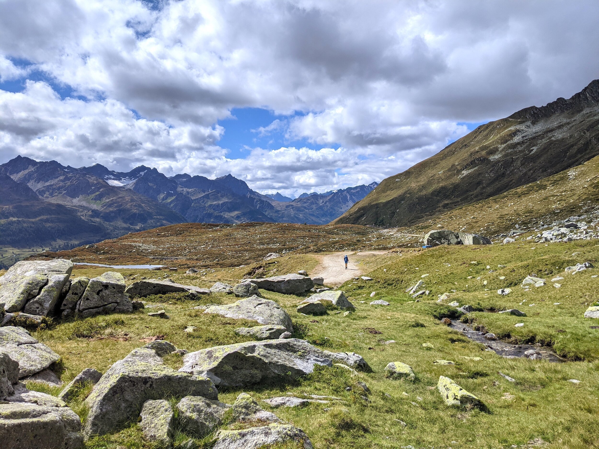
Join Nina over 5 days in the Swiss Alps as we follow route 49 - the Vier Quellen-Weg (‘Four Springs Trail’). This route spans 3 cantons in central Switzerland - Uri, Ticino and Valais. We traverse over six mountain passes - the Maighels, Sella, Gottard, Lucendro, Nufenen and Furka - and encounter diverse vegetation, including pine forests, wetlands with streams, moors, lakes and rocky high altitude peaks with glaciers and fascinating geology. The four source springs we encounter are, the Rhine, Reuss, Ticino and Rhône. The last stage is a particular highlight as the Rhône is our constant companion. We follow it right up to the Rhonegletscher (glacier), where the hike concludes with views across Obergoms and beyond!

Climate for Vier Quellenweg
The Swiss Alps in August is sublime Average temperatures range from 7 - 25 degrees celsius. The air is bursting with the aromas of fragrant wildflowers, and is peppered by the mineral spray of mountain spring water. When in high altitude, the weather can be very changeable. At times, the skies are flawlessly blue, and the afternoons mild and lingering, and at other times, a cold burst of rain and cold can pass over. You have to be prepared for all weather conditions in the mountains, and anticipate chilly to fresh mornings and evenings even when the skies are clear. August is the driest month of the year in Switzerland.

Fitness and hiking experience
This 81km route over 5 days has been carefully planned. We will cover 4600m ascent gain in total, and journey through pristine wilderness, keeping to very well-marked hikers’ paths. It is recommended that you are fit, comfortable with being on your feet for ±7hours, and have some experience of mountain hiking. On day 3, 4, and 5 we will hike over 17kms each day. We will be carrying our own backpacks. If you are unsteady and hesitant, then the rocky, steep sections are going to be a tough challenge for you. This hike is not suitable for unfit people. You are responsible for your own preparation in the lead up to the hike.

5 Day hiking route from Oberalpass to Furkapass


Day-by-Day Overview of the Hiking Route
Day 1
Andermatt - Oberalppass - Vermigelhütte
Distance: 14.2km | Ascent: 726m | Descent: 768m | Est. time: 6hrs
-
We meet at Andermatt train station, and catch the 10:28 train to Oberalppass as a group. The train takes roughly 10mins. Upon arrival at Oberalppass, we walk up a small hill and pass 2 restaurants that are handy for any last minute toilet stops, or espresso and snack raids. Just beyond the second restaurant, we cross the road and are faced with the first official sign of the VIer Quellen Weg. The hike begins! We follow a path that snakes adjacent to the road for around 30minutes, and then veer to the right and begin climbing. At a t-junction, we take a right and start a series of switch-backs up to Lai da Tuma (2344m) - an atmospheric mountain lake that serves as a lovely place to stop for a snack. This is the 1st of 4 source springs over the hike; the source of the Rhine.
Leaving Lai da Tuma, we clamber over rocks and an undulating path until we arrive on the escarpment overlooking a high altitude valley with the Rein da Maighels running through it. We pass Camona da Maighels CAS hut, which can serve as a lunch stop, and then proceed up the valley towards our fist mountain pass - Pass Maighels (2420m). At the top of the pass we are treated with 3 gorgeous lakes, all on the edge of the ridge, creating an ‘infinity pool’ effect! From there we begin a descent into Vermigelboden. On the way down, there are tantalising views of our 1st night hut. Vermigelhütte (2040m) sits atop a hill, and the last bit of effort for the day is surprising and spicy - about a 50m/100m climb straight up.
Day 2
Vermigelhütte - Gotthard Pass
Distance: 12.4km | Ascent: 753m | Descent: 687m | Est. time: 6hrs
-
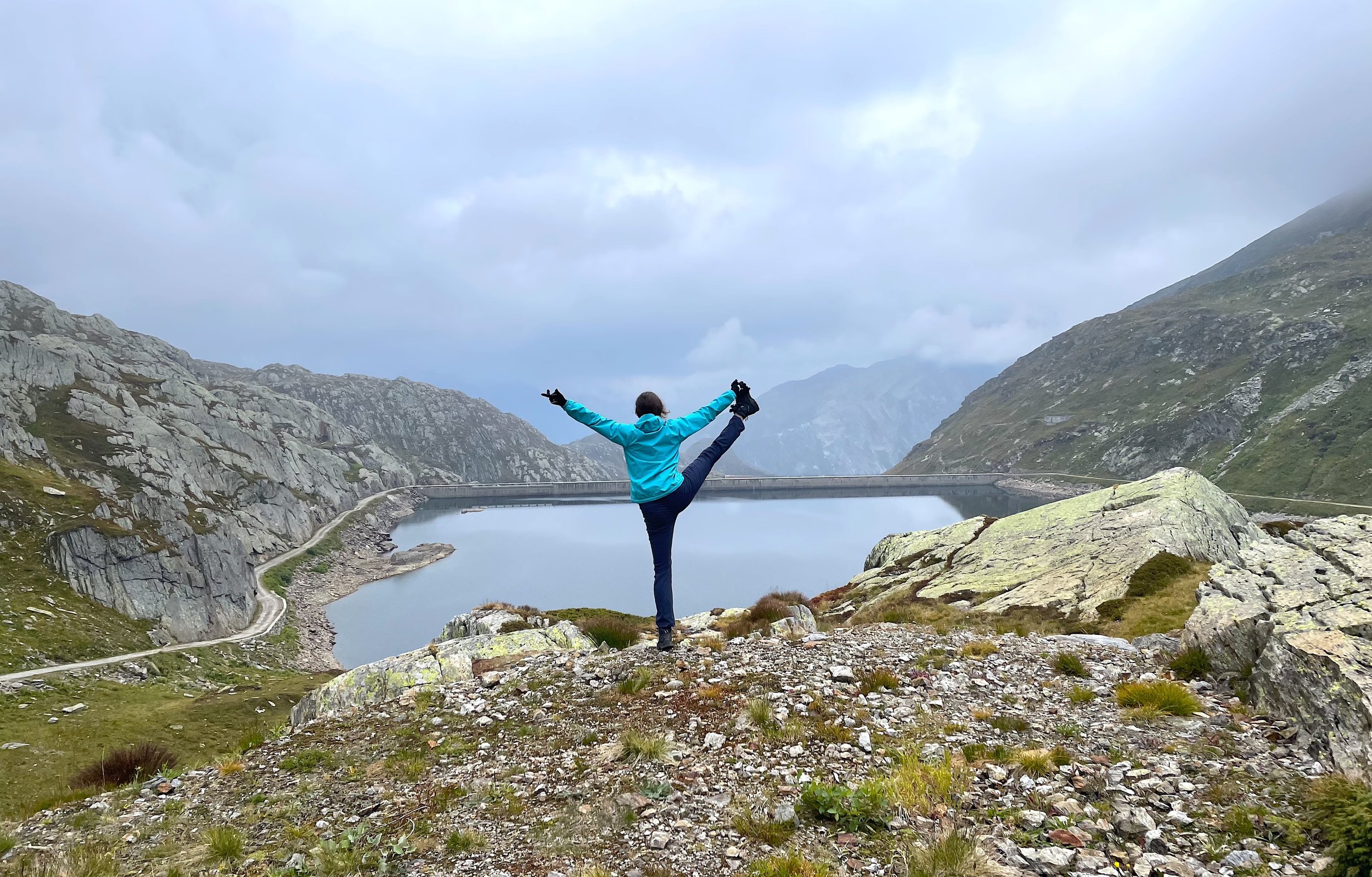
We depart from Vermigelhütte to in the opposite direction from which we arrived. We climb up Sunnsbiel, with the Bortwasser stream running alongside the path. The incline is gradual at first, and very easy under foot as we traverse up sloping grasslands. However, it is a 750m climb in total, so after about 1hr30m, the path becomes more rocky and steep. As we approach Passo della Sella (2776m) we have to clamber over rock and shale, and there are some patches of snow, still in tact over the summer months. Look out for chamois herds! From the pass, the views are to Airolo, Val Canaria, and the Italian border on one side, and back towards the snowy peaks of Gemstock (2962m) and Chastelhorn (2973m) on the other. The way down to Lago della Sella is steep in sections, but very well sign posted. From the Ovi della Sella, we will begin to get glimpses of this majestic lake, and have the choice to skirt around the edge of the lake towards the right, or to stick left and head straight for the dam wall. There are a number of lovely places to stop around Lago della Sella. From the bridge, we join with an old concrete road and begin to descend into Passo del San Gottardo. We follow Lago dei Morti en route, and navigate towards the Albergo San Gottardo, our hotel stay for the night.
Day 3
Gotthard Pass - Capanna Piansecco SAC
Distance: 20km | Ascent: 724m | Descent: 833m | Est. time: 7hr30min
-
We depart from Vermigelhütte to in the opposite direction from which we arrived. We climb up Sunnsbiel, with the Bortwasser stream running alongside the path. The incline is gradual at first, and very easy under foot as we traverse up sloping grasslands. However, it is a 750m climb in total, so after about 1hr30m, the path becomes more rocky and steep. As we approach Passo della Sella (2776m) we have to clamber over rock and shale, and there are some patches of snow, still in tact over the summer months. Look out for chamois herds! From the pass, the views are to Airolo, Val Canaria, and the Italian border on one side, and back towards the snowy peaks of Gemstock (2962m) and Chastelhorn (2973m) on the other. The way down to Lago della Sella is steep in sections, but very well sign posted. From the Ovi della Sella, we will begin to get glimpses of this majestic lake, and have the choice to skirt around the edge of the lake towards the right, or to stick left and head straight for the dam wall. There are a number of lovely places to stop around Lago della Sella. From the bridge, we join with an old concrete road and begin to descend into Passo del San Gottardo. We follow Lago dei Morti en route, and navigate towards the Albergo San Gottardo, our hotel stay for the night.
Capanna Piansecco - Obergesteln
-
We start the day with a gradual climb up to the foot of the Val Bedretto, with the Italian border on our left. We meet a road and just off that, a small organic goat’s cheese farm! The farm shop is usually open and this is a great place to grab some goat cheese to add to your lunch on this rather long stage 4. After the farm shop, we cross under a small bridge and join the winding source spring of the Ticino river. This is the 3rd of our 4 springs! From there, it’s straight up to Nufenenpass (2441m). The route is well marked and good under foot. Right near the top there are more tricky rock sections. The top of the pass offers some of the best views and most dramatic scenes of the whole hike. Look out for chamois and ibex, and gaze across at the stunning Fieschergletscher and Grosser Aletschgletscher, the largest glacier in Switzerland. Spot the peaks, Grosses Grünhorn (4044m) and Finsteraarhorn (4274m). In the distance lies the mighty Jungfrau (4158m).
From Nufenenpass we begin a very long descent into the Obergoms valley via Agenetal. The beginning of the descent is very steep and requires some patience. At Ladstafel, there is a potato and cheese stall (with chilled beverages and coffees) run by a clump of burly mountain farming lads. Soon thereafter, we cross a 13th century bridge and descend further, disappearing into pine forests, crossing over a suspension bridge and eventually re-emerging in the Obergoms. We walk through Ulrichen and swing right for 15min before reaching the very comfortable and somewhat fancy Hotel Hubertus in Obergesteln (1355m).
Day 5
Obergesteln - Belvédère, Furka Pass
-
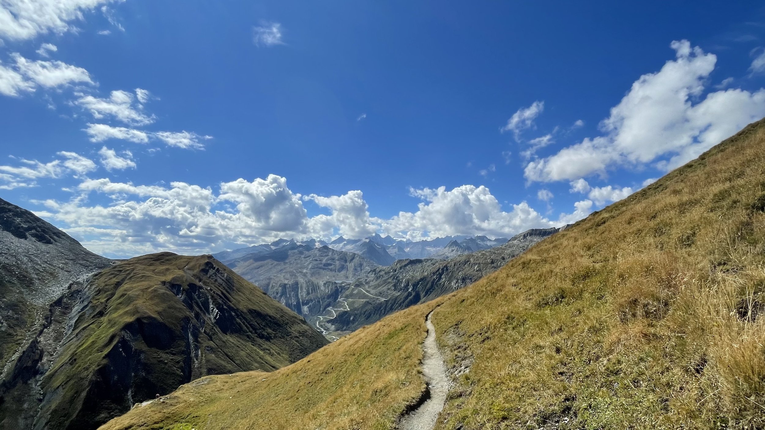
The last stage of the Vier Quellen-weg is spectacular! This is one of the most diverse and enjoyable days of hiking I have ever done. We depart Obergesteln and walk along the flat Obergoms valley to Oberwald. From Oberwald we begin the days climb in earnest. After an hour weaving in and out of pine trees, we emerge on a grass slope, peppered with wild blueberries and raspberries. The Rhone is our constant companion throughout this stage, and just before Gletsch (1757m), there is a spectacular stone bridge and views up to Grimselpass and Furkapass (don’t be intimidated!). Gletsch has a charming mountain hotel with a bustling cafetaria. Find a table amongst the bikers and roadsters for a coffee and tart, or lunch. It is shocking to consider that in 1880, the Rhone Glacier stretched right up to Gletsch! Global warming has had a devastating effect on the Rhone.
The path veers to the right of the Gletschbode and continues far right to the historic train station, Muttbach-Belvédère (2117m). From here the climb up to Furkapass gets really steep. There is a ‘false top’ around 70% of the way up, and the last section is very steep, but footing is steady and reliable. The climb is not completely over at Furkapass, we do not stay on the road, but rise above it on a footpath and there is around 50m ascent remaining to reach 2474m. From here, the views of Grimselpass, Obergoms and Finsteraarhorn (4272m) are unforgettable. We traverse around the front of Gross Furkahorn and on towards Rhonegletscher, the source of the Rhone river, and the 4th of 4 source springs. The ending to this hike is such a highlight! However, one cannot help but notice the sorry state of the glacier and devastating effects of global warming. The Belvédère hotel is a scene out of many films (including the Bond classic, Goldfinger), and this is the end point of the Vier Quellen Weg.
Day 4
Distance: 19.78km | Ascent: 673m | Descent: 1217m | Est. time: 7hr40min
Distance: 17.2km | Ascent: 1230m | Descent: 315m | Est. time: 7hr30min

FAQ’S
Some of your questions answered
-
Yes! We have a detailed packing list for you - please contact us so we can share it with you :-)
-
This is a nature immersion and hiking holiday, with daily meditation and yoga. It is not a yoga retreat in the sense that yoga is not the main focus. The main focus are the mountains! We will be doing guided meditation and functional movement for 20mins every morning, and 1hour of chilled, accessible yoga for all levels in the afternoon. There is plenty of exercise to be had with all the hiking, so our yoga practice on this holiday is to calm the mind, cultivate presence, and support the body. I find yoga to be a wonderful accompaniment to hiking. I find my legs are so much fresher and lighter because I always do the right kind of chilled yoga in the evenings after a big day of hiking. All yoga sessions have to be done outside, and so if we are unlucky and have very wet conditions, this may effect the timing and duration of the yoga sessions.
-
The route is accessible to someone who is fit and steady on their feet. You do not have to be an experienced hiker to complete this, but you must be comfortable with spending long hours on your feet and carrying a pack. There are some steep climbs and descents, so I highly recommend you bring hiking poles, to help with footing and stability. Please have a look at the route descriptions and details above on this page. You will see that Day 3, 4 and 5 are quite long (±17km each day)! The fitter you are when you start the hike, the more you will enjoy it. If you do not train in advance of the hike and are unfit, you are opening yourself up to possible injury and a lot of discomfort. You will also slow the rest of the group down, and may be forced to miss out on sections, which is not fun for anyone :-(
-
Each night stay is unique. On night 1 and 3 we stay in hiker’s cabins in remote mountain locations. Each cabin has a large kitchen and dining area with cozy fireplaces; bathrooms; ski / hiking boot room; dorm bedrooms, ranging from 2 bunk beds p/room to 10+ beds per room; and shared bathrooms. Where possible, our group will have a dorm room we all share, or smaller rooms where you will be paired with someone from our group. The beds are comfortable and clean. There are pillows, duvets and blankets. You will not need to bring a sleeping bag. You will need to bring a sleeping bag liner. They are very remote hiking cabins, they are not luxury hotels. They are designed for communal living. It is strongly advised you bring a pair of earplugs and an eye mask. There is hot water, toilets and showers in the communal bathrooms.
On night 2 and 4, we stay in mountain hotels. They are 3- and 4-star hotels respectively, where you will be in a bedroom sharing 1 other person. There will be 2 single beds in the room that you can push together to make a queen bed if you are travelling with your partner. Hotel bathrooms are shared with 1 or 2 other rooms from our group.
-
Included in your hiking holiday package is breakfast and dinner.
Breakfast: Freshly baked bread, butter, cheese, preserves, milk/yogurt and museli. There is always fresh coffee, teas, and fruit juice.
Dinner on night 1 and 3 - at hikers’ huts: The food is always made with pride and care; it is simple and wholesome. For dinner expect regional specialities like polenta with cheese, mountain mushrooms and cream, potato rosti, stews, fondue, soups, salad, and a small desert. The huts will accommodate vegetarians. The huts also have regional wine and beer for sale, softdrinks, and a la carte menus throughout the day.
Dinner on night 2 and 4 - at a restaurant: I have chosen a restaurant for our group on these two nights as we are staying at hotels. The restaurants have a la carte menus with a range of options, including vegetarian options. Expect regional dishes and local ingredients. Included are 2 courses. Beverages and dessert are at your own expense.
All of us will arrange our own lunches. This is best because when hiking, people want/need different types of foods at different times over the day. It is recommended that if you have a particular type of hiking food you love, then bring that with you!
-
On night 1, Vermigehütte only accepts cash, and small cafes and farmers stalls along the route also on accept cash. The 2 hotels we stay at, and both restaurants we will go to for dinner on night 2 and 4, accept credit cards. I recommend you bring some Swiss Francs with you (or Euros are also sometimes accepted, but you will get Swiss Francs in change). I would bring ±200 CHF in cash per person, and a credit card.
-
The best location to stay the night before and after the hike is in Andermatt. For hotel and b’nb recommendations, please ask Nina.
-
Booking Terms
A non-refundable deposit payment is required to secure your booking.
Balance payment is required 30 days prior to retreat start date.
If booking between within 30 days before start date, 100% payment is required to secure booking.
Cancellation terms
All payments are non-refundable.
In the event the Hike and Yoga in Switzerland holiday is cancelled due to unforeseen circumstances, we will set new dates in the future. 100% of payments made will go towards the new dates. If these dates don’t suit you, we can issue refunds.
It is recommended that you get your own travel insurance.
Contact us with questions about this InRetreat
